A day hike through the Ribeira Grande on the island of
Santiago (Cabo Verde)
|
|
|
|
|
||
This map is an adaptation
of
|
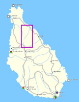
The island of Santiago with
|
Click on the map
The map on the right side is a |
Map of
the hiking route,
|
| Shortly you can also click for the Portugese version |
|
![]()
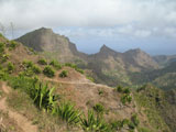
The island of Santiago, one of the 12 inhabited islands of
Cabo Verde), offers a number of opportunities for hiking.
Dit is de mooiste wandeling, die ik op dit eiland gelopen
heb. This hike is the finest hike I have made on
this island. Deze wandeling is onder normale droge
omstandigheden niet moeilijk, maar kan bij regen of wel moeilijk zijn.
This hike is not difficult under normal dry conditions, but can be difficult in
wet situation. Maar de regen valt slecht in
beperkte mate in de periode juli tot en met september.
But the rain is limited to the period of July to September.
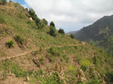
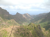
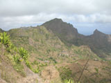
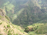
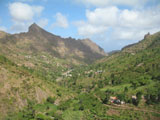
De wandeling gaat door het
Parque
Natural Serra Malagueta. De start van de wandeling is op 750 meter in het
gehucht Serre, dat aan de doorgaande weg van zuidoost Santiago naar noordwest
Santiago ligt.
The hike goes through the Parque Natural Serra Malagueta. The start of the hike
is on a height of 750 m in the hamlet of Serre, that is on the road from
southeast to northwest Santiago.
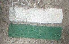
The hike is up to the first village marked with a marking of a green and a white
stripe.
De paden, die verkeerd zijn, worden aangegeven met een
groen/wit kruis (vergelijkbaar met het kruis bij LAW paden in Nederland, Belgi�,
Frankrijk en Spanje). The paths that are wrong, are indicated with a
green / white cross (similar to the cross used on long distance paths in the
Netherlands, Belgium, France and Spain).
|
This
picture can not be enlarged
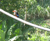
Right: At division of paths is sometimes (but
not always) the right path indicated by a marking of a green stripe with
a white stripe above it |
 |
I made this hiking trip with Marianne R. gemaakt op 31
december 2009, tijdens een tweeweekse reis naar de Kaapverdische eilanden (Cabo
Verde). on December 31, 2009, during our holidays of two weeks on Cabo
Verde.
We sleep in the city Praia on the southern end of the island.
We zijn deze dag met een busje vanuit naar Assomada gegaan,
dat midden op het eiland ligt. This day we went with a bus to Assomada
in the middle of the island.
Daar stapten we over op het busje rihting Tarrafal.
There we boarded for a bus in the direction of the city Tarrafal in the north of
the island. Ongeveer halverwege die reis, stappen we rond
11.00 uur in het bergplaatsje Serre uit, op 750 meter hoogte. About
halfway that journey, we leave the bus (around 11.00 o�clock) in the mountain
village of Serre, at 750 meters altitude. Daar blijkt een
straffe passaatwind te waaien, waardoor het even koud is. On this height
there appears to be a pain trade winds to blow, making it equally cold.
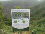
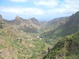
Aan de rechterkant van de weg vinden we al snel een
informatiebord over het voetpad, dat door het dal gaat. On the right side
of the road we soon find an information board on the footpath that goes through
the valley.
|
The large photo is 136 Kb
Right:
Information board at the start of the hike at Serre |
 |
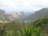
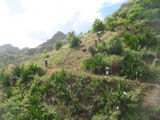
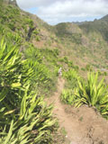
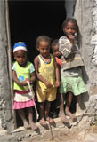
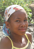
Left of the billboard is a small mountain path that descend into the
valley. Op dat pad zien we ook Kaapverdianen lopen, met
bagage op hun hoofd. On that path we see Cape Verdeans walk with luggage
on their heads.
|
The large picture is 123 Kb
Right: From the road at Serre we can see the path below us,
where Cabo Verdeans walk with bags on their heads |
|
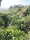
We take this path.
We kiezen steeds bij splitsingen het breedste pad of het
pad, waarvan we kunnen zien, dat het nog veel verder loopt. Maar regelmatig
worden we ook geholpen door de aanwezigheid van markeringen. On divisions
we choose to always take the widest path or the path of which we can see that it
goes much further. But we are also regularly helped by the presence of markings.
We twijfelen soms bij huizen, die we passeren, maar de
mensen zijn vriendelijk: ze wijzen ons het goede pad. We sometimes
hesitate near houses we pass, but the people are friendly: they show us the
right path.
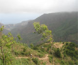
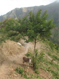
On our way to the first
town I make a large number of photos, I represent some of them below.
 |
 |
 |
 |
 |
 |
 |
 |
 |
 |
 |
 |
 |
 |
 |
 |
 |
 |
 |
 |
-
The description below will soon be
supplemented with photos
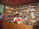
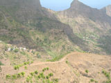
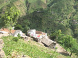
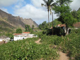
After about two hours we reach the first village, that has been called Principal (170 m). Daar komen we ook het eerste cafeetje tegen, waar we even wat drinken.In this village we surpass the first bar on our hiking trip, so we get a drink.
|
The large picture is 148 Kb
Right:
Bar in the village Principal |
|
From the village we travel behind a dirt road, which takes us to the
coast. Over this gravel road regularly drives buses, which bring people from the
village to the coast and the seaside to the village market.
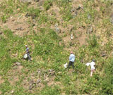
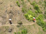
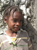
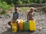
Onderweg zien we twee kinderen met jerrycans, die
wachten op vervoer.
We see two children with jerry cans, waiting for
transport.
 |
The large pictures are respectively 186 and 88 Kb
Left:
Children with jerry cans full of water, waiting for transport
Photos: Fred Triep |
 |
The unpaved road is in the beginning a river, most of the year dry. This road is the lowest point of the valley. After some time we come back to a village. Behind this village is the road a separate paved road to the right of the river.. We follow this road and arrive at the coast road. There we have to wait fifteen minutes until a bus comes along, that bring us back to the south along the coast
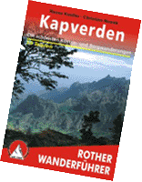
| Rasso Knooler & Christian Nowak Kapverden- Die sch�nsten K�sten- und Bergwanderungen- 50 touren Rother Wanderfűhrer, 2007 ISBN 978 3 7633 4275 4 Bestellen of bekijken bij Rother Bergverlag |
|
| Aisling Irwin & Colum Wilson Cape Verde Islands Bradt Travel Guides ISBN-13: 9781841622767 Bestellen of bekijken bij Bradt Travel Guides |
|
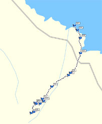 |
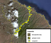
Map on the left:
map of the available track and waypoints
During this hike I used my Garmin Oregon 300 GPS to store tracks and
waypoints
Dit materiaal is beschikbaar als
mps file (Mapsource formaat van Garmin) en als
gdb file (garmin GPS database formaat).This
material is available as
mps
file (in Garmin Mapsource format) and as a
gdb
file (Garmin GPS database format).
Note: The background image of the map on the left is the Mapsource Worldmap and this map is really coarse. We hebben dus niet in de zee gelopen, zoals dit kaartje suggereert. So, we have not hiked into the sea, as this map suggests. |
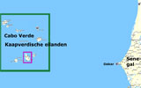
There are no
detailed maps to get from the Cabo Verde islands.
Er is een
overzichtkaart van Freytag & Berndt, waarop alle eilanden staan:
There is a general map of Freytag & Berndt, on which all islands are
represented.
| Kapverdische Inseln Auto + Freizeitkarte Freytag & Berndt, schaal 1:80.000 prijs � 9,95 Ordering or viewing at Freytag & Berndt |
|
On the under mentioned pages you will find more information on this hike or hike
or on the island of Santiago:
This new page was created on Tuesday, November 23, 2010.
![]()
For additions or comments, send me an email
![]() email : Fred Triep
email : Fred Triep